Weather returns to a more normal pattern, heat is in the mix
Wednesday’s forecast calls for cloudy conditions through mid-morning before gradually clearing, with a high near 91 degrees. South winds will blow 10 to 15 mph with gusts up to 20 mph.
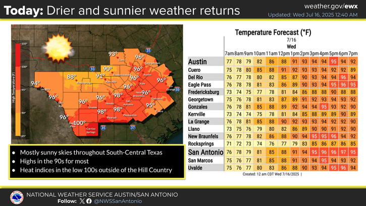
After two weeks of stormy weather, Kerr County residents can expect a return to clearer skies and rising temperatures through the weekend, according to the National Weather Service.
Wednesday’s forecast calls for cloudy conditions through mid-morning before gradually clearing, with a high near 91 degrees. South winds will blow 10 to 15 mph with gusts up to 20 mph.
The evening will bring mostly clear skies with a low around 69 degrees and south-southeast winds of 5 to 10 mph, gusting to 20 mph.
Thursday will be mostly sunny with a high near 92 degrees under south winds of 5 to 10 mph. Thursday night will be partly cloudy with a low around 68 degrees as winds calm after midnight.
Friday continues the sunny trend with a high near 90 degrees. Calm morning winds will shift to south-southeast around 5 mph. Friday night will be partly cloudy with a low around 72 degrees.
The weekend outlook shows mostly sunny conditions Saturday with a high near 91 degrees and south winds of 5 to 10 mph. Saturday night will be partly cloudy with a low around 72 degrees.
Sunday brings mostly sunny skies with a high near 93 degrees. South winds will blow 5 to 10 mph with gusts up to 20 mph. Sunday night will be partly cloudy with a low around 72 degrees.
According to the National Weather Service, subtropical ridging expanding from eastern Texas will bring drier mid-level air and largely rain-free conditions to the region. The Hill Country will see temperatures in the upper 80s to low 90s, while areas along Interstate 35 eastward and Highway 90 southward will experience mid to upper 90s.
Heat indices in the warmest areas are forecast to reach the low to mid-100s.
The weather service said an upper-level low over coastal northern Mexico will move farther southwest Thursday, allowing the ridge to expand further into the area while maintaining dry conditions.
Looking ahead to the weekend and early next week, forecasters expect broad ridging to expand across the southern United States. While this pattern will bring warm temperatures, they are expected to remain near average for mid-July, with daytime highs in the upper 90s and nighttime lows in the 70s.
The expanded ridge should facilitate dry conditions heading into the weekend and next week. However, meteorologists are monitoring potential tropical development in the northern Gulf of Mexico. Current models suggest the system will remain well to the east, making landfall along the central Gulf coast.
A brief coastal surge of moisture associated with the disturbance could bring isolated rain showers to the Coastal Plains on Friday, but effects for the rest of South-Central Texas are expected to be minimal.
Author

Related Articles

Concordia sweeps Saturday doubleheader to claim series from Schreiner
The Schreiner University softball team dropped both ends of a Saturday doubleheader to Concordia University Texas, 13-4 and 6-4

The Lead Live Podcast: Tuesday, Jan. 13, 2026 episode
The broadcast included a recap of the previous day’s Commissioners Court meeting, where officials approved a “platinum” flood warning system in partnership with UGRA and Kisters North America.

Comments (0)
There are no comments on this article.