National Weather Service warns of all severe hazards tonight; retired meteorologist calls it potentially ‘one of the most dangerous days’ of the season
Hail, tornadoes and damaging winds expected to peak overnight across southern Edwards Plateau and western Hill Country
The National Weather Service’s Austin/San Antonio office has issued a Level 3 of 5 risk for severe thunderstorms across the southern Edwards Plateau and western Hill Country for Tuesday afternoon into tonight, with all severe hazards possible — including very large hail, tornadoes, damaging winds and localized flash flooding.
Retired meteorologist and American Red Cross volunteer Richard McAlister, who appeared Tuesday on The Lead Live, said the setup warrants the highest level of concern.
“Potentially this could be one of the most dangerous days that we have of our entire severe weather season, even though it’s coming very early in the season,” McAlister said.
How the storms develop
Forecasters say conditions will remain relatively quiet through the morning, with scattered showers and isolated thunder possible as an upper low approaches from the west and a Pacific moisture plume moves into Texas. The NWS forecast discussion, issued at 1:23 a.m. Tuesday, anticipates the cap holding across much of the region through 7 p.m. — but warns that shortly after, “explosive development” is likely, with supercell activity producing all severe weather types initially, followed by bowing squall line segments later into the evening.
“This favorable pattern for the bowing segments means that a potential for brief tornadoes could last into the late night hours as storms remain intense over the Hill Country and Rio Grande Plains,” the NWS discussion states.
After 3 to 4 a.m. Wednesday, inflow support for the squall line is expected to weaken as it pushes toward the Interstate 35 corridor, though the NWS cautioned that a brief re-deepening of the upper low as it crosses Texas could trigger new discrete cell development near the leading edge — meaning the metro area threat should not be dismissed.
By 7 a.m. Wednesday, the severe threat is expected to have cleared. A sunny, drier day follows with highs in the 70s.
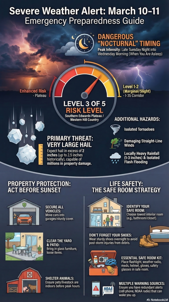
Hail is the primary threat
McAlister identified very large hail as the top hazard, with the NWS forecast consistent with that assessment. Hail could exceed 2 inches in diameter, posing significant danger to vehicles, roofs and property.
“That’s actually the largest threat today is for the hail,” McAlister said.
Tornado and damaging wind threats are closely related. The NWS forecast discussion specifically notes the potential for bowing segments — a storm structure associated with destructive straight-line winds — and brief tornadoes lingering well into the overnight hours.
McAlister said the overall atmospheric setup closely mirrors a destructive storm system from last March, but with more raw energy available.
“Severe weather is kind of like a stew. You need to have all of the ingredients,” he said. “We have nearly double the amount of ingredients that we would need for the severe weather.”
Flooding a secondary concern
The NWS has also issued a Level 1 to 2 of 4 risk for locally heavy rainfall and isolated flash flooding across the southern Edwards Plateau and western Hill Country. Forecasters anticipate 1 to 3 inches of rainfall, with isolated higher totals possible where slow-moving cells cause training — repeated rounds of heavy rain over the same area.
“We might anticipate a couple areas where some severe discrete cells moved slow enough that the developing line trained a second round of heavy rain, to warrant a Flash Flood Warning,” the NWS discussion states.
McAlister called flooding a secondary concern relative to the hail threat, and noted that runoff impacts in more populated areas should be limited given that prior rainfall hit only in isolated spots.
Overnight timing amplifies danger
Both the NWS and McAlister emphasize that the nocturnal nature of the event substantially raises the stakes.
“We’re going to reach the peak threat just about the time that people are going to bed into the very early A.M. hours tomorrow morning,” McAlister said. “And that’s perhaps the most frightening thing about this — we know that the fatality rate essentially doubles for nocturnal severe weather events because people are not paying attention to the alerts.”
He urged residents to ensure they have multiple ways to receive weather warnings overnight, including devices capable of waking them from sleep.
Recommended preparations
McAlister offered specific steps residents should take before the storms arrive this evening:
— Move vehicles into a garage or under cover before dark.
— Bring in patio furniture, particularly glass tables, and shelter pets and livestock.
— Stock an interior room on the lowest floor of the home — such as a bathroom — ahead of time with a flashlight, a radio, medications, a bicycle helmet, work gloves and safety glasses.
— Keep shoes accessible. “A lot of the times the injuries that we see following severe weather are people that have stepped on broken glass or nails or slipped,” McAlister said.
‘Emotionally vulnerable’ community
McAlister closed his remarks by placing the storm threat in the context of a community still absorbing the trauma of the past year — the July 4 flood that killed 119 people countywide, a destructive hail event and an outbreak of fires.
“We’re in a period right now where we need to really be prepared as a community to absorb any additional shock that comes to us in the forms of weather because we’re emotionally vulnerable right now,” he said.
Author

Related Articles

Joy Ann Lozano: Dec. 2, 1943-March 11, 2026
She will be remembered most for her thoughtful and caring nature.

Mildred Ford Saunders: July 7, 1928-March 10, 2026
It was at S.M.U., where she met the love of her life, Clyde Saunders.

Samuel Jones: Nov. 3, 1947-March 8, 2026
He retired from the U.S. Army Reserve in 1994 with the rank of Lieutenant Colonel.
Comments (0)
There are no comments on this article.