Tornado Watch issued as escalating severe weather threat moves toward Kerr County tonight
NWS now forecasting winds up to 80 mph, hail exceeding 2 inches; storm development arriving sooner than expected
A Tornado Watch is in effect for portions of the southern Edwards Plateau tonight as a rapidly escalating severe weather threat pushes toward Kerr County — with forecasters now warning of earlier storm development, stronger winds and heavier rainfall than predicted just hours ago.
The National Weather Service’s Austin/San Antonio office issued the watch Tuesday afternoon in collaboration with the Storm Prediction Center for Val Verde County and portions of the southern Edwards Plateau through 10 p.m. CDT. Extensions in both time and area are possible. All hazards are in play.
The NWS is now forecasting damaging winds up to 80 mph, hail exceeding 2 inches in diameter and rainfall totals of 2 to 4 inches on the southern Edwards Plateau — an increase over earlier projections. The flash flood risk has also expanded eastward into the Hill Country and portions of the northern I-35 corridor. The Kerrville forecast carries a 90% chance of precipitation tonight, with storms possible through 4 a.m.
Storms are expected to develop over West Texas and Val Verde County late this afternoon — sooner than earlier forecasts indicated. They will be supercellular initially, producing large hail and tornado risk, before organizing into a squall line with increasing wind potential. The NWS warns that brief tornadoes cannot be ruled out across the southern Edwards Plateau and Hill Country even after storms form into a line. The most intense activity is expected to reach the Kerrville area by late evening and persist into the early morning hours.
Retired meteorologist and American Red Cross volunteer Richard McAlister, who appeared on Lead Live Tuesday morning, said the setup is unlike anything seen so far this year.
“Potentially this could be one of the most dangerous days that we have of our entire severe weather season,” McAlister said.
He warned that the overnight timing is the most dangerous element — storm fatality rates essentially double for nocturnal events because people are asleep and miss alerts.
The severe threat is expected to diminish after 4 a.m. Wednesday, with dry conditions returning by Wednesday evening.
Residents should act now: move vehicles under cover, bring in patio furniture and pets, stock an interior room with a flashlight, radio, medications, helmet, gloves and safety glasses — and ensure they have a weather alert that will wake them overnight.
Author

Related Articles

Suspect in juvenile assault arrested after overnight manhunt on I-10
David Bryan Cox Jr., 44, was arrested at approximately 11:05 a.m. Friday
Man wanted on assault charge armed and dangerous, Kerr County sheriff’s office says
A witness told authorities Cox was armed with at least one firearm and was wearing a ballistic vest and a gun belt loaded with multiple magazines. He was last seen wearing white basketball shorts.
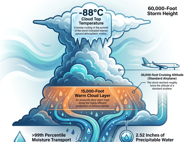
The monster in the canyon: What the storm actually was — and what was never asked
Nine months after the flood, federal meteorologists tell the full story. In 15 hours of legislative testimony this week, none of it came up.
Comments (0)
There are no comments on this article.