Schools close Monday, Kerr County roads remain hazardous but limited issues during storm
Kerrville Independent School District, Ingram Independent School District, Center Point ISD and Hunt ISD all announced closures for Monday. Ingram ISD also announced a delayed start for Tuesday.
Multiple Kerr County school districts and Schreiner University announced closures for Monday as local officials reported residents are largely staying off icy roads and the winter storm has caused minimal impacts so far.
Kerrville Independent School District, Ingram Independent School District, Center Point ISD and Hunt ISD all announced closures for Monday. Ingram ISD also announced a delayed start for Tuesday.
Schreiner University announced it will be closed Monday due to sustained subfreezing temperatures and icy conditions throughout the region. All classes — including labs, flight instruction and clinicals — are canceled. Administrative offices will also be closed, though staff will monitor email remotely.
Campus dining options will remain limited. The Schreiner Diner and Lion’s Den will maintain special hours, while the C-Store will be closed. The university urged all students, faculty and staff to avoid travel and remain indoors.
The closures come as an Ice Storm Warning, Winter Storm Warning and Winter Weather Advisory remain in effect through noon Sunday, with roads across Kerr County frozen and covered by sleet and freezing rain.
“Road conditions are less than ideal and people should use extreme caution,” Kerrville City Manager Dalton Rice said Sunday. “Expecting some thawing today with refreezing tonight.”
Rice said the city will make the decision to close City Hall around 7 p.m. Sunday night.
Sheriff: Call Volume Lower Than Expected
Kerr County Sheriff Larry Leitha said residents are heeding warnings to stay off the roads.
“Yes, it’s going very well. We were very prepared and still are,” Leitha said Sunday. “People are lost and staying off the roads for the most part. We still have 24 hours to go but the call volume has been lower than expected.”
The National Weather Service continues to warn that travel is not recommended across South-Central Texas as many roads will remain ice-covered even though precipitation is ending Sunday morning.
Power Outages Minimal
Kerrville Public Utility Board General Manager Mike Wittler said the utility has experienced minimal impacts from the winter storm.
“Things have been pretty quiet for us and we pray they stay that way,” Wittler said Sunday. “We had an outage in the Scenic Hills area this morning affecting 144 customers for about 45 minutes.”
Wittler said KPUB has also had several customers with tripped breakers and asked residents to check their breakers before calling if they experience an outage.
“As always, crews are on standby 24/7 if needed,” Wittler said.
The brief outages demonstrate the strain on electrical infrastructure during extreme cold events when heating demand spikes.
Refreezing Danger Tonight
While sunshine will help melt some ice Sunday, any water will quickly refreeze after sunset, making roads icy again Sunday night into Monday morning. This refreezing cycle will prolong travel impacts into the work week.
An Extreme Cold Warning continues through noon Monday and may be extended into Tuesday morning as no change in the Arctic airmass is expected. Travel impacts could linger into Monday and Tuesday due to residual icy roads.
Ice Totals
Total ice accumulations remain on track with forecasts. The Ice Storm Warning area covering the Hill Country received one-quarter to one-half inch of ice. Most of the remainder of the region under Winter Storm Warnings received one-tenth to one-quarter inch with isolated amounts of one-quarter to one-half inch.
Sleet accumulations up to one-half inch are possible in most areas.
Dangerous Cold Continues
Dangerously cold Arctic air continues across the region. Northerly winds of 10 to 20 mph with gusts to 30 mph will send wind chills as low as 5 below zero across northern areas and 5 degrees above zero across southern areas.
Lows in the teens are expected across most areas Sunday night into Monday morning, except for areas of single digits in the Hill Country and lower 20s along the Rio Grande.
These conditions may cause hypothermia and frostbite if precautions are not taken. The weather service warns: “Keep people, pets, plants and pipes warm, and practice safe use of space heaters.”
Precipitation Ending
The enhancement of precipitation ahead of an upper-level trough over the Big Bend moved through overnight. The trough will exit to the east shortly after sunrise, taking the precipitation with it.
Another upper-level trough passes overhead by early evening Sunday with a few snow flurries possible over Val Verde County, though no snow accumulations are expected.
Week Ahead
Although some temperature recovery is expected the remainder of the week, conditions will remain unseasonably cold. Freezes with areas of hard freezes are expected at night into early morning due to efficient radiational cooling, with only Thursday night mostly above freezing.
A cold front and upper-level trough will move across the area Friday into next weekend to generate precipitation, with forecast soundings indicating a possible mix of precipitation types. Models have been inconsistent, and forecasts in coming days will provide more details.
Author

Related Articles

Kerrville Council leans toward tiered stormwater fee, but delays decision pending more study
The proposed fee is designed to generate roughly $267,000 in its first year for system maintenance while chipping away at a $15 million backlog of drainage capital projects identified in the city’s 2020 Stormwater Master Plan.
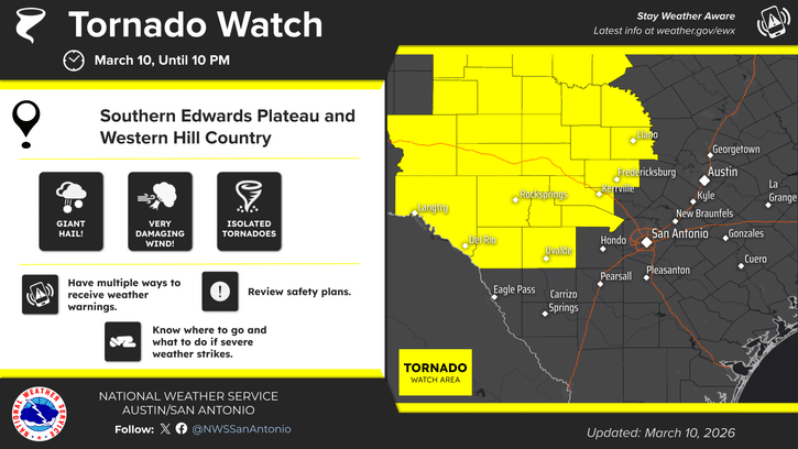
Tornado Watch issued as escalating severe weather threat moves toward Kerr County tonight
NWS now forecasting winds up to 80 mph, hail exceeding 2 inches; storm development arriving sooner than expected
Judge grants partial injunction against Camp Mystic, blocks office use for Cypress Lake reopening
Judge Maya Guerra Gamble of the 459th Judicial District issued the ruling after a day-long hearing in the Steward family’s wrongful death lawsuit. Her order took effect immediately, she said, even as attorneys work on final written language.
Comments (0)
There are no comments on this article.