
In one week, this storm rivaled the wettest July on record — set in 2002
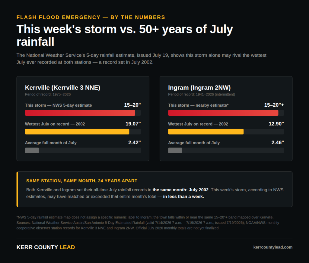
NWS 5-day rainfall estimate puts Kerrville at 15 to 20 inches; more than 50 years of station data shows that’s in the range of, or beyond, the wettest full month of July ever recorded here
Thursday’s flood didn’t just overwhelm Kerr County’s creeks and rivers. Preliminary estimates suggest it may have rivaled, or even surpassed, the wettest July ever recorded in Kerrville — a record that has stood for nearly a quarter-century.
The National Weather Service’s five-day estimated rainfall map, issued Sunday morning and covering July 14 through July 19, puts total rainfall over Kerrville at 15 to 20 inches. Immediately to the west, between Kerrville and Rocksprings, the map shows an even more extreme, unlabeled band of rainfall reaching into the darkest category on the NWS scale — areas that may have seen 20 inches or more.
To understand how extraordinary that is, The Lead compared the estimate against more than 50 years of monthly rainfall data from the National Weather Service cooperative observer station at Kerrville 3 NNE. Since record-keeping began at that station in 1975, the wettest July on record delivered 19.07 inches — in July 2002. The average July total across that entire 52-year record is just 2.42 inches.
In other words: if the NWS’s five-day estimate holds up, this week’s storm alone may have matched or exceeded the wettest calendar month of July this area has ever recorded — in less than a week, rather than 31 days.
The pattern repeats at Ingram. Records at the Ingram 2NW station, stretching back intermittently to 1941, show a July record of 12.90 inches — also set in July 2002. The average July total there is 2.46 inches.
The same month, 24 years apart
Both of Kerr County’s long-standing rainfall stations set their all-time July records in the exact same month: July 2002, a flood remembered across Central Texas for widespread, catastrophic flooding along the Guadalupe and other Hill Country rivers. That this week’s storm appears to rival that benchmark — in a fraction of the time — underscores how extreme Thursday’s rainfall was, even by the standards of a region well acquainted with flash flooding.
Official monthly totals for July 2026 are not yet finalized at either station; standard NWS cooperative observer reporting lags behind real-time events, and this month’s figures are still marked as pending in the network’s records. The NWS’s five-day rainfall estimate, generated from radar and available gauge data, offers the best current picture of what fell, but it is an estimate, not a final confirmed total.
The rainfall wasn’t confined to Kerr County. The same NWS map shows an even larger core of extreme rainfall stretching toward Rocksprings and Del Rio to the west, with Uvalde — hit hard by this week’s flooding as well — estimated at 10 to 15 inches.
Author

Related Articles

Where to find help: A guide to flood recovery resources in Kerr County
As Kerr County continues recovering from Thursday’s flooding, a wide network of local, regional and national organizations has mobilized to help residents and business owners. Here’s a complete guide to who’s involved and how to reach them.
Residences and businesses in need of assistance
People who need assistance

Comments (0)
There are no comments on this article.