Severe storms possible in Kerr County today; threat continues through the week
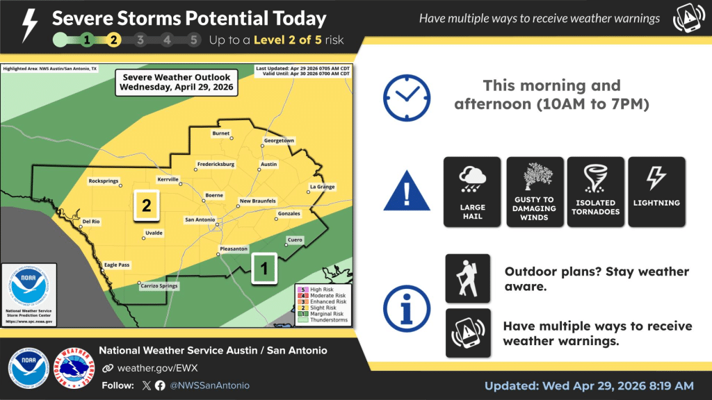
National Weather Service places Kerrville in Level 2 of 5 severe weather risk zone through this evening
Kerr County faces a chance of severe thunderstorms today and an unsettled weather pattern through Friday as a pair of cold fronts push through the region this week, according to the National Weather Service in Austin/San Antonio.
The NWS has placed Kerrville in a Level 2 of 5 severe weather risk zone for Wednesday, with the primary threat window running from 10 a.m. to 7 p.m. Forecasters identify large hail as the most likely hazard, with gusty to damaging winds, isolated tornadoes and frequent lightning also possible. Residents should have multiple ways to receive weather warnings in place before midday.
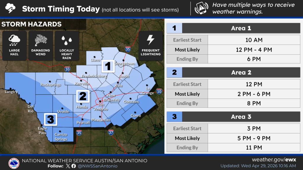
For Kerr County, storms are most likely between 2 p.m. and 6 p.m., with an earliest possible start of noon and activity expected to end by 8 p.m., according to the NWS storm timing outlook. Not all locations will see storms.
The overall storm chance today is 60%, with showers and possible thunderstorms most likely between 1 p.m. and 4 p.m. The high will reach near 84 with northeast winds at 5 to 10 mph. Rainfall totals will generally be less than a tenth of an inch, though higher amounts are possible in thunderstorms.
Tonight will see a brief lull, with only a 20% chance of showers and thunderstorms and a low around 62.
The bigger concern arrives Thursday. An 80% chance of rain and storms is forecast for Thursday night, with some storms capable of producing heavy rainfall. NWS forecasters have flagged the Southern Edwards Plateau and Hill Country as the areas most likely to see the highest rain totals as an upper-level shortwave trough moves through the region. The high Thursday reaches near 77 before temperatures drop further.
Friday brings an 80% chance of showers and possible thunderstorms, a high near 66, and north-northeast winds gusting to 25 mph before a second push of cooler air clears the frontal boundary from the region.
The weekend turns drier and noticeably cooler, with lows dropping into the mid-40s to mid-50s Saturday morning.
Residents should monitor conditions throughout the day. For the latest watches, warnings and advisories, visit weather.gov/EWX or follow @NWSSanAntonio on social media.
Author

Related Articles

Lt. Gov. Patrick calls on DSHS to stop Camp Mystic from operating, demands Eastlands withdraw license application
The state’s second-highest official enters the fray — and Camp Mystic’s own attorney has already called him a Judas
Camp Mystic faces mounting pressure to close as nine hours of testimony culminate in mother’s extraordinary plea
From legislative scolding to a surgeon’s indictment to a grieving mother turning her back on the Legislature to face the Eastlands directly, Tuesday’s hearing left little doubt about where the investigation is heading

State emergency chief details Kerr County failures, calls for overhaul of Texas disaster response
Chief Nim Kidd, director of the Texas Division of Emergency Management, testified before the joint General Investigating Committee on the July 2025 Flooding Events, delivering both a frank accounting of local failures and a set of proposed legislative reforms he said are long overdue.
Comments (0)
There are no comments on this article.