Ice storm arrives early; freezing rain now coating Hill Country roads
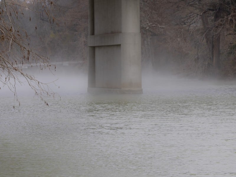
Friday night’s storms produced significantly higher rainfall totals than predicted in parts of Kerr County. While forecasts called for 0.5 to 1.5 inches on average with isolated spots of two to three inches, observed rainfall amounts reached 2 to 5 inches in Bandera and Kerr counties.
The dangerous ice storm forecasters warned about has arrived in Kerr County, with freezing rain now coating roadways across the Hill Country after heavier-than-predicted rainfall dumped two to five inches across Bandera and Kerr counties overnight, causing flooding.
The National Weather Service started the Winter Storm Warning at 3 a.m. Saturday, three hours earlier than the predicted 6 a.m. start time, as subfreezing temperatures entered northern portions of the Edwards Plateau, Hill Country and Interstate 35 corridor.
Rain is now freezing on contact as surfaces become frozen across the region. Water on roads from the earlier heavy rains is also beginning to freeze, creating extremely hazardous conditions.
“These wind chills and temperatures are similar to the February 2021 outbreak,” the weather service stated early Saturday, referencing the devastating winter storm that crippled Texas five years ago.
The Winter Storm Warning remains in effect through noon Sunday. An Extreme Cold Warning begins at 6 p.m. Saturday and continues into Monday.
Why Ice, Not Snow?
Many residents are wondering why this storm is producing freezing rain instead of snow. The answer lies in atmospheric conditions thousands of feet above the ground.
Forecast soundings show a strong mid-level warm layer with temperatures above freezing — up to 50 degrees Fahrenheit — keeping freezing rain as the favored winter precipitation type. This “warm nose” of air aloft melts falling snow into rain, which then refreezes when it hits the subfreezing surface.
However, a deepening lower-level subfreezing layer and weakening mid-level warm nose may allow for some sleet and possibly some snow toward the end of the event Sunday morning as the atmosphere cools throughout the column. Any snow accumulation would be minimal and occur only as the system exits.
This atmospheric setup makes freezing rain — not snow — the primary threat, and freezing rain is far more dangerous. Ice coats everything it touches and can snap tree limbs, down power lines and make roads impassable.
All Travel Extremely Dangerous
Significant travel impacts began early Saturday morning as rain transitioned to freezing rain. Icy weather will continue into Sunday morning, but travel impacts could linger into Monday and Tuesday on residual icy roads.
All unnecessary travel should be avoided. Roads are becoming ice-covered as conditions deteriorate in real time.
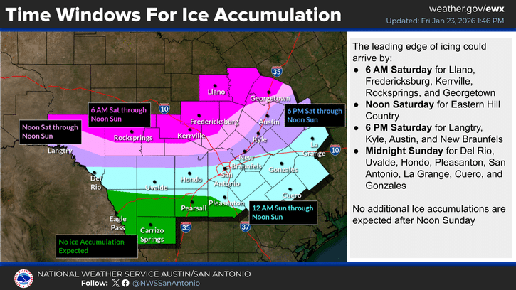
The weather service expanded winter weather warnings Saturday morning to include the U.S. Highway 90 corridor between San Antonio and Del Rio, with significant ice accumulations expected mainly across the northern portions of those counties. A Winter Weather Advisory was added for Winter Garden areas for minor ice accumulations.
Higher Rainfall, Some Flooding
Friday night’s storms produced significantly higher rainfall totals than predicted in parts of Kerr County. While forecasts called for 0.5 to 1.5 inches on average with isolated spots of two to three inches, observed rainfall amounts reached 2 to 5 inches in Bandera and Kerr counties.
The Arctic cold front and an upper-level impulse generated showers and isolated thunderstorms with locally heavy rains and small hail overnight. The heavier rains caused some flooding before the transition to ice began.
Most areas received less than one inch of additional liquid precipitation overnight, though isolated higher amounts were recorded.
Ice Accumulation Forecast
Ice accumulations of one-tenth to one-quarter inch are expected, with isolated accumulations of one-quarter to one-half inch possible across Winter Storm Warning areas and up to one-tenth inch in Winter Weather Advisory areas.
Precipitation intensity waned somewhat during early morning hours as the initial impulse moved away, keeping additional ice accumulations low temporarily. However, intensity will increase late Saturday afternoon into evening as an upper-level trough over Baja California approaches the area, enhancing ice accumulations again.
The subfreezing temperatures and associated freezing rain will continue spreading south through the day into evening. The Winter Storm Warning issued for the San Antonio area begins at 3 p.m. Saturday, though forecasters are monitoring trends for a possible earlier start.
The upper-level trough moves east by midday Sunday, ending precipitation and allowing Winter Storm Warnings and Winter Weather Advisories to expire at noon Sunday.
Dangerously Cold Arctic Air
In addition to wintry precipitation, dangerously cold Arctic air has arrived. Northerly winds of 10 to 20 mph with gusts to 30 mph will send wind chills as low as 5 below zero across northern areas and 5 to 10 degrees above zero across southern areas.
Lows in the teens are expected across most areas, except lower 20s along the Rio Grande and isolated single digits in the Hill Country. Some guidance is trending colder than ongoing forecasts.
Wind chills at these levels can cause hypothermia and frostbite if precautions are not taken.
The weather service warns: “Remember to protect the four P’s: People, Pets, Plants and Pipes.”
Extended Freeze, Refreezing Danger
Although some temperature recovery is expected next week, conditions will remain unseasonably cold with freezes expected at night into early morning across most areas. These temperatures will enable any water on roads to refreeze, prolonging hazardous travel conditions.
A long-duration freeze is forecast for portions of the Hill Country and Austin metro area through at least Monday morning. Some areas may remain below freezing until Tuesday afternoon.
Pet Shelter Available
Kerrville Pets Alive has set up a pet crate and supply area at Calvary Temple Church, 3000 Loop 534 in Kerrville. People and non-aggressive, crated pets are welcome.
Pet owners in need may call 844-572-7387.
Animals in distress should be reported to Kerr County Animal Services at 830-257-3100, Kerrville Police Department at 830-257-8181 or the Kerr County Sheriff’s Office at 830-896-1133.
Kerr County asks residents to refrain from trapping animals in freezing temperatures.
City Facilities Closed
The city of Kerrville announced several facilities are closed this weekend:
- Butt-Holdsworth Memorial Library: Closed Saturday
- Kerrville Golf Course: Closed through Sunday
- City Landfill: Closed Saturday
City parks remain open, however park restroom facilities are closed to help prevent pipe bursts and leaks. Campers at Kerrville-Schreiner Park have access to winterized restroom facilities.
For non-emergency issues, residents may contact the city at 830-257-8181.
Another Winter Storm Possible Next Weekend
Another cold front and upper-level trough will move over the area late next week into next weekend, generating another round of precipitation. Forecast soundings indicate precipitation will start as rain, then become a mix of winter precipitation types with snow currently the favored type going into next weekend.
Forecasts in coming days will refine details of the second winter system.
Shelter in Place
With ice now coating roads and dangerous cold arriving tonight, residents should shelter in place and avoid all travel. Power outages are possible and could last for an extended period.
Residents should:
- Stay off roads through the weekend
- Keep pets indoors
- Have alternative heating sources ready
- Conserve food and water supplies
- Check on elderly neighbors by phone
- Know location of water shut-off valves
The city of Kerrville encourages everyone to stay safe and warm.
Author

Related Articles
Ice Storm Warning issued for Kerr County; travel may become ‘nearly impossible’
Travel conditions are deteriorating in real time as intermittent showers and drizzle add to ice accumulations and standing water from Friday night’s locally heavy rains freezes over. Icing is being observed on increasingly longer stretches of roads and highways across Kerr County.

Quarter-inch of ice forecast for Kerrville arrives at 6 a.m. on Saturday, creating hazardous continutions
A quarter-inch of ice represents a critical threshold where Ice Storm Warning criteria begins, according to the National Weather Service. At this accumulation level, ice coats surfaces like clear cement, trees begin shedding branches under the weight, and roads become extremely hazardous.
Comments (0)
There are no comments on this article.