The monster in the canyon: What the storm actually was — and what was never asked
Nine months after the flood, federal meteorologists tell the full story. In 15 hours of legislative testimony this week, none of it came up.
A note from the editor
Quality journalism is expensive — and The Kerr County Lead runs on the support of readers who believe local news matters.
Many of our paying subscribers urged us to make this story available to everyone. So we did. If it informed you, moved you, or helped you understand what happened here, consider supporting our continued work with a small gift.
Every dollar helps us Build the Lead — and keep stories like this one free for the community that needs them most.
[Contribute $1 or more →]
Nine months after the flood, federal meteorologists tell the full story. In 15 hours of legislative testimony this week, none of it came up.
At 12:56 a.m. on July 4, 2025, a meteorologist at the National Weather Service office in Austin sent a message through its professional communications platform: “Some cell mergers about to take place in central Kerr County. This will be an area to watch for potential flash flooding.”
Eighteen minutes later, a flash flood warning went out to cell phones across the Hunt area — the ninth such warning issued for the Guadalupe River corridor since 2020. The previous eight had all expired without a mass casualty event.
By 4:03 a.m., NWS had upgraded that warning to a Flash Flood Emergency — the most urgent alert the agency can issue. Kerr County Emergency Management Coordinator Dub Thomas was home sick that night. Whether anyone else in Kerr County’s emergency structure was actively monitoring professional NWS channels during those critical hours remains unknown.
At 3:51 a.m., Camp Mystic director Dick Eastland’s Apple Watch had already registered as submerged.
Nine months after 119 people died along the Guadalupe River, federal meteorological agencies have released their comprehensive scientific account of what happened. The StoryMap Collection, produced in coordination with NWS San Angelo, the West Gulf River Forecast Center, the National Water Center and the Weather Prediction Center, traces the disaster from its atmospheric origins in late June through the final warnings issued as the surge moved downstream through Kerrville toward Comfort. The OIG Report, “NWS Actions Relevant to the Catastrophic Flash Flood in Texas,” was released earlier this month as well.
What the StoryMap documents is not a story of warnings ignored or officials asleep at the switch. It is something more complicated: a warning system that performed at the outer edge of its design limits, in conditions that exceeded anything that design was built to handle, in a community where the line between a routine alert and a catastrophic one was functionally invisible until it wasn’t.
This week, the Texas Legislature’s joint General Investigating Committee on the July 4, 2025, flood convened two days and nearly 20 hours of testimony examining what went wrong at Camp Mystic. The science — the storm, the atmosphere, the canyon, the structural limits of the warning system — was not discussed. When the committee’s own lead investigator, Casey Garrett, was asked directly whether her team had consulted a meteorologist, she answered simply: no. No committee member followed up on that answer.
While the science behind the weather systems, how they were tracked and interpreted, and the details of the amount and velocity of the wall of water traveling down the river early July 4 may not matter to the general investigating committee but they may to the public, especially those in Hunt and West and will most certainly matter for the ongoing lawsuits and any criminal negligence investigation that may be pursued.
“Concerning”
At 7:10 in the evening on July 3, 2025, a meteorologist at the National Weather Service Weather Prediction Center in College Park, Maryland, sent a message to forecasters across Central Texas.
The subject was the Texas Hill Country. The summary line read: “Concerning trends for back-building and training thunderstorms over the Texas Hill Country this evening that could produce more than 3 inches per hour max rainfall rates.”
One word. Concerning.
Inside that bulletin — written in the dense shorthand of professional meteorology — was a near-precise description of what was about to happen. The mesoscale convective vortex was identified. The low-level jet accelerating out of South Texas overnight was identified. The moisture at the 99th percentile of all previously observed rates for this time of year was identified. The specific mechanism — back-building and training storms that would lock over the same terrain for hours — was identified.
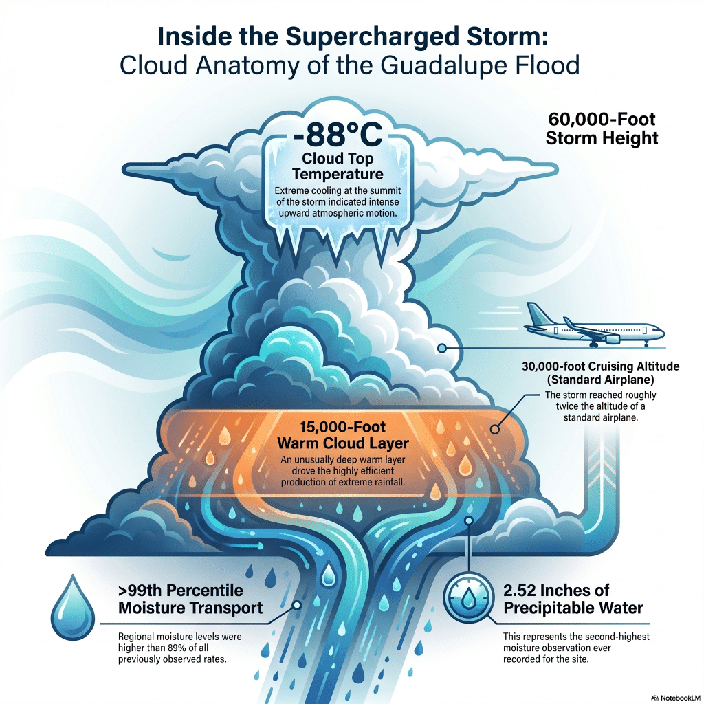
The bulletin noted that atmospheric moisture was running above 2.2 to 2.5 inches, above the 99th climatological percentile. It noted that the low-level jet would “gradually accelerate out of South Texas” overnight, continuously feeding the storm system. It noted that integrated vapor transport — the rate at which moisture was being pumped northward — was above the 97.5th percentile. It noted that warm cloud layers were 15,000 feet deep “in many cases.” It stated that flash flood guidance thresholds in parts of the Hill Country “would have little problem” being exceeded.
To a meteorologist, that bulletin — issued at 7:10 p.m., more than six hours before the surge killed 28 people at Camp Mystic — was a serious warning.
To nearly everyone else, “concerning” is the word you use when your teenager is staying out too late. It is not the word that moves a camp director to wake his staff, or prompts a county emergency manager to activate resources, or causes a family at a riverside cabin to load the car and drive to higher ground.
That gap — between what “concerning” communicates inside a professional meteorological context and what it communicates to the rest of the world — is not a gap that opened on July 4. It is a structural feature of the warning system. Technical precision and public urgency are not the same language. On most nights, that doesn’t matter. On the night of July 3 into July 4, 2025, it mattered enormously.
Six hours after that bulletin was sent, the rain gauge six miles southwest of Hunt recorded 5.22 inches in a single hour. The Guadalupe River at Hunt rose more than 30 feet in 95 minutes. At 3:51 a.m., Dick Eastland’s Apple Watch registered as submerged.
“Concerning” was the right word for what forecasters saw at 7:10 p.m. It was not a word that could carry the weight of what was coming.
How big was the flood?
To understand what happened to the Guadalupe River on July 4, 2025, start with what it normally looks like.
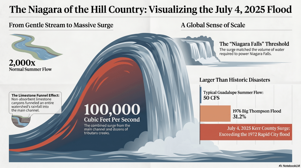
On a typical summer day in Kerrville, the Guadalupe runs at 10 to 50 cubic feet per second — a gentle current, shallow enough to wade. By 4 a.m. on July 4, volumetric data compiled by Kerr County Engineer Charlie Hastings documented the main channel carrying approximately 83,000 cubic feet per second. Cypress Creek, Edmonson Creek and dozens of limestone tributary channels added thousands more. The combined surge approached 100,000 cubic feet per second.
That is roughly 2,000 times the river’s normal summer flow.
The number requires a frame of reference. The 1976 Big Thompson Canyon flood in Colorado — one of the deadliest flash floods in American history, which killed 139 people — peaked at 31,200 cubic feet per second. The 1972 Rapid City flood, which killed 238 people when Canyon Lake Dam failed and sent a wall of water through a sleeping city, reached 50,000 cubic feet per second. Both events are remembered as catastrophic. The July 4 surge through the Guadalupe canyon was larger than either.
The most precise comparison is Niagara Falls.
By international treaty, a minimum of 100,000 cubic feet per second must flow over Niagara Falls during daylight hours in tourist season to maintain the falls’ appearance. The combined surge documented by Hastings — rainfall pouring off an entire limestone watershed in the Texas Hill Country — approached that same threshold.
Niagara Falls draws 30 million visitors a year to watch that volume of water move. On July 4, it moved through a canyon between Hunt and Kerrville while most residents slept.
The river rose because the sky emptied itself onto an entire watershed at once. Limestone canyons do not absorb. They funnel.
Hastings, who served as Kerr County Engineer, compiled the volumetric analysis before his death. His data remains the most detailed accounting of what the canyon carried that morning.
Why July was supposed to be different
July is typically one of the driest months in Central Texas, averaging just one to three inches of rainfall. In most summers, a large high-pressure ridge keeps the region under dry, sinking air and pushes tropical moisture south. But July has also produced some of the Hill Country’s most catastrophic floods: in 1987, storms near Hunt dropped over 11 inches, and in 1932, more than 35 inches fell in 36 hours over the upper Guadalupe basin, sending floodwaters to within inches of the Camp Mystic dining hall stairs.
The landscape concentrates the risk. The steep slopes and exposed limestone bedrock of the Edwards Plateau shed water rapidly, funneling rainfall into rivers with almost no absorption. Going into the summer of 2025, the region had been in exceptional drought — soils parched, the landscape primed to shed rather than hold whatever fell.
A stacked deck: how the atmosphere loaded
The conditions that produced the July 4 disaster began taking shape more than a week before the flood.
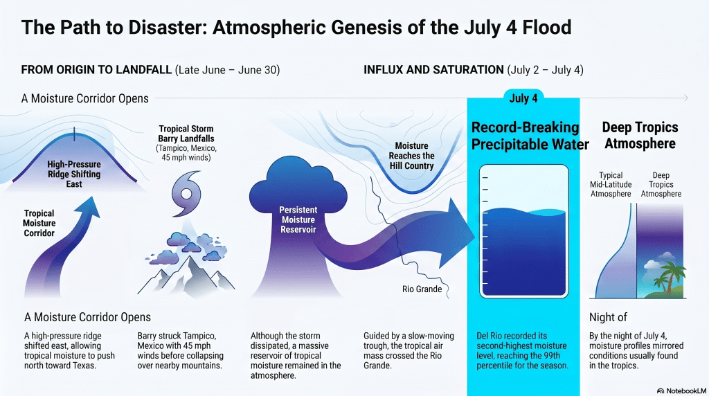
In late June, a high-pressure ridge shifted east, opening a corridor for tropical moisture to push north into Texas. On June 29, Tropical Storm Barry made landfall near Tampico, Mexico, roughly 275 miles south of the border. By most measures, Barry was modest: it existed as a tropical storm for barely 12 hours, with peak winds of 45 mph, before its circulation collapsed over the mountains of northeastern Mexico. It killed eight people in Mexico — flooding neighborhoods in Tampico, overflowing the Tamesí River, affecting 5,000 families — before dissipating on June 30.
What didn’t dissipate was the enormous reservoir of tropical moisture Barry had drawn northward out of the Bay of Campeche. Guided by a slow-moving trough developing over northwestern Mexico, that moisture rode north along the Sierra Madre Oriental, crossed the Rio Grande and spread across the Hill Country by the evening of July 2.
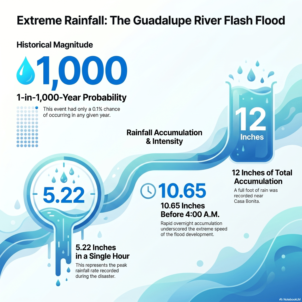
Weather balloons captured what was happening to the atmosphere. Moisture transport into Central Texas at times exceeded the 99th percentile of all previously observed rates for this time of year. By the morning of July 4, a balloon launched from Del Rio recorded 2.52 inches of precipitable water — the second-highest observation at that site on record. The atmosphere over the Hill Country that night, the StoryMap notes, carried moisture profiles “resembling the very humid conditions typically found in the deep tropics.”
The feature forecasters hadn’t fully seen coming
On the evening of July 2, a complex of thunderstorms developed over southern Chihuahua and moved into the Big Bend area by early July 3. As it organized, something specific developed: a mesoscale convective vortex, or MCV — a rotating storm system that, on satellite imagery, can resemble a tropical cyclone over land. MCVs are, the StoryMap notes, often difficult to predict and challenging to model accurately even with high-resolution tools.
In a saturated environment, MCVs can be self-sustaining for far longer than individual thunderstorms, repeatedly triggering new storm development. This one was already causing flooding along Interstate 10 through West Texas as it moved east on July 3, prompting flash flood warnings and pushing the Rio Grande to major flood stage at multiple points. By evening, it had reached the Hill Country.
The combination of the MCV, the slow-moving trough, and the saturated airmass converging on the same terrain created an atmospheric environment, as the StoryMap describes, “significantly supportive of heavy rain.” Every parameter that matters for extreme rainfall — moisture, storm motion, atmospheric instability — was aligned in the worst possible configuration.
A conveyor belt of storms
Around 10 p.m. on July 3, storms developed between Fredericksburg and Uvalde, cutting across Kerr County. By midnight, intense thunderstorms had moved into the county, and what followed is described meteorologically as storm training: individual cells moved northward, tracking directly over the South Fork of the Guadalupe watershed. At the same time, their outflow collided with an intensifying surge of moisture from the south — moisture so steady it continuously triggered new storms to form in exactly the same place, following exactly the same path. Instead of one storm passing through and the land getting a break, storm after storm rolled over the same ground for hours.
The storms themselves were of a scale rarely seen over the Hill Country. Satellite data from NOAA-20 detected cloud tops at negative 88 degrees Celsius, meaning the convective towers had punched through the tropopause — the boundary of the lower atmosphere — and into the lower stratosphere at roughly 60,000 feet, nearly twice a commercial airliner’s cruising altitude. That vertical depth mattered: below those towering columns, a layer of above-freezing air extended 15,000 feet deep, giving raindrops an unusually long distance to grow and merge before reaching the ground, which drove rainfall rates above five inches per hour.
NASA’s Global Precipitation Measurement satellite, passing over the complex that morning, captured it in three dimensions: deep convective towers with frozen precipitation at altitude and columns of intense rain driving straight down. The atmosphere over the South Fork was not merely wet. It was a 12-mile-tall engine, running at full power, anchored in place.
A band of 7 to 12 inches of rain fell over the South Fork watershed, most of it in just three hours.
The data no one had
The only recognized rain gauge on the South Fork during the flood was located near Casa Bonita — downstream of Camp Mystic. It recorded 12 inches before rain briefly paused around 4 a.m. A separate gauge roughly six miles southwest of Hunt recorded 10.65 inches, including 5.22 inches in a single hour.
But there was no rainfall data west of Casa Bonita. The heaviest rain fell over the upper South Fork watershed, west of every camp on the river, west of every gauge, west of every instrument that might have told someone what was coming. There was also no stream gauge on the South Fork itself. What the river was doing in the critical hours before 3:30 a.m. was, in instrument terms, invisible.
Scientists estimate the three-hour rainfall totals over the South Fork carried a 1-in-1,000-year probability — a 0.1% chance of occurring in any given year. Even across a full 24 hours, the totals represented a 1-in-200-year event. Most flood infrastructure is designed around 1-in-100-year events. A common misconception is worth stating plainly: a 1-in-1,000-year event does not mean the region is safe from a similar event for the next millennium. The odds reset every year.
This is the scientific context that was entirely absent from two days of legislative testimony this week. When Sen. José Menéndez — the committee’s only Democrat and the member who came closest to raising the science — asked investigator Casey Garrett about the rate of rise at the confluence near Hunt, noting from prior research that the river appeared to rise approximately 29 feet in roughly 45 minutes, Garrett confirmed the investigators had not examined that question. No other member pursued it.
The committee spent nearly 13 hours establishing what people did and did not do in the hours before the surge arrived. It did not spend a single minute examining what the surge actually was.
The geo-fence no one discussed
Tuesday’s hearing produced one piece of new scientific context — almost inadvertently. Testimony confirmed that the CODE RED wireless emergency alert issued by the National Weather Service that night was geo-fenced to western Kerr County, specifically the Hunt area.
That means any emergency manager, county official or city official living outside of Hunt — including in Kerrville, roughly 20 miles east — did not receive that alert on their phone. The people responsible for coordinating Kerr County’s emergency response largely lived outside the fence.
Combined with the OIG report’s finding that NWS staff could not reach those same officials by telephone — because 911 dispatch was already fielding 87 calls from the Hunt area in a single hour — the warning system failed Kerr County’s emergency management apparatus on two separate channels simultaneously.
No committee member asked the question that finding demanded: if the most urgent wireless alert of the night never reached the county officials responsible for ordering a response, how much of what the hearing characterized as local incompetence was in fact a structural failure of the warning infrastructure? That question went unasked. It remains unanswered.
What the warning system saw — and when
The StoryMap assembles something not previously available in a single public document: a detailed timeline of what forecasters communicated to the public alongside what they were telling emergency managers and professional partners through internal channels simultaneously. Read side by side, those two records tell a story of widening divergence as the night progressed.
More than 14 hours before the first flash flood warning, the Weather Prediction Center had flagged a Level 2 of 4 risk for excessive rainfall across the Hill Country. By early afternoon on July 3, NWS Austin/San Antonio had issued a flood watch and emailed situation reports to nearly 2,000 regional partners. By evening, internal meteorological discussions warned of back-building and training thunderstorms capable of producing more than 3 inches per hour, with flash flood guidance thresholds that “would have little problem” being exceeded. To a trained meteorologist, those bulletins described something potentially catastrophic.
To most people — including, almost certainly, most of the families whose children were sleeping at camps along the South Fork — a flood watch and a Level 2 of 4 risk communicated something more like routine summer caution. The public advisory that evening warned of 1 to 3 inches of rain, with isolated amounts of 5 to 7 inches possible across a multi-county region. Nothing in it indicated that one specific watershed was about to receive a 1-in-1,000-year rainfall event.
That gap did not close as the night progressed. It widened.
At 1:14 a.m., the flash flood warning reached phones in the Hunt area. It was the ninth issued for this corridor since 2020. The previous eight had all expired without fatalities. Three had been issued in the six weeks immediately before July 4, all uneventful. Kerr County Emergency Management Coordinator Dub Thomas, home sick that night, was not monitoring the escalating alerts.
Thomas later explained to the Legislature’s Special Select Committee why he did not issue a manual alert. “During this incident, I did not issue an additional IPAWS alert because the National Weather Service had already triggered more than a dozen alerts, which all provided a similar forecast — be aware of the potential for isolated flash flooding, anticipate rain in the range of between one and three inches, possibly as much as seven inches.”
What Thomas could not have known was that the rainfall on the South Fork was already running at more than twice that estimate and accelerating — and that the forecast he was relying on would not materially change until after 4:03 a.m.
At 2:28 a.m., NWSChat warned that the area was “now at about 200% of rainfall to flash flood guidance” and that “flash flooding has likely begun.” At 3:02 a.m.: “A very dangerous flash flood event is unfolding across south-central Kerr County.” At 3:19 a.m., public alerts began directing people to “Move to higher ground now. Act quickly to protect your life.”
By 3:30 a.m., the first fatality had already occurred at River Inn, just west of Camp Mystic. By 4 a.m., there were likely multiple fatalities at Camp Mystic. At 3:57 a.m., NWSChat messaged: “We are also upgrading the Flash Flood Warning to a Flash Flood Emergency.” The public declaration followed at 4:03 a.m.
By the time the most urgent alert the National Weather Service can issue reached phones in Hunt, people were already dead.
The question the StoryMap cannot answer
The NWS StoryMap is, by design, an account of what the National Weather Service did. It documents a system that performed with genuine urgency and increasing precision. What it cannot document is what happened to those warnings once they left the NWS system.
Thomas addressed that directly in his legislative testimony. “To those who have asked, ‘What would you have done differently?’ The honest answer is that based on the data we had at the time, there was no clear indicator that a catastrophic flood was imminent. The rain fell in remote areas with limited gauge data. The situation evolved faster than anyone could have predicted.”
That answer points to the structural gap Thomas himself identified as the most urgent priority going forward. “We need better data,” he told legislators. “We need real-time monitoring of rainfall and river gauges, especially in upstream headwaters and watershed zones. We cannot rely solely on radar or traditional forecasting from the National Weather Service.”
It is a striking moment of clarity. The emergency management coordinator for Kerr County, testifying under oath before the Texas Legislature, identified the exact gap that two separate federal documents have since confirmed: no stream gauge on the South Fork, no rainfall data west of Casa Bonita, no real-time visibility into the watershed that produced the catastrophic surge. Thomas didn’t have that data. NWS didn’t have it either. Nobody did.
The OIG report adds one more layer the StoryMap does not address: the warning coordination meteorologist position at the NWS Austin/San Antonio office — the role specifically responsible for bridging what forecasters know and what emergency managers understand and act on — had been vacant since spring, when its previous holder took an early retirement as part of federal workforce reductions. It was not filled until November 2025. Two other positions were also recently vacated due to “workforce optimization incentives” — DOGE cuts: the Science and Operations Officer and the Observing Program Leader.
Whether these vacancies affected what happened downstream of the NWS system is an open question. The StoryMap does not raise it. The OIG report documents it without resolving it. The record is now public.
The flood moves downstream
By 5:34 a.m., a downstream Flash Flood Emergency was issued for the Guadalupe from Hunt through Kerrville and Center Point, declaring “a large and deadly flood wave is moving down the Guadalupe River.” The Guadalupe at Hunt had crested at 37.51 feet — a record, narrowly surpassing the 1932 flood. The flood wave reached Comfort by 9:58 a.m. The river there rose 26 feet in 45 minutes.
What the NWS record shows, read alongside the gaps in measurement infrastructure and emergency staffing that night, is not a story of warnings ignored or danger dismissed. It is a story of a warning system working at the edge of what it was designed to do — in conditions it had never been designed to handle — delivering increasingly precise and urgent information through channels that reached professionals but not the people sleeping in cabins along the South Fork.
What the Legislature didn’t ask
The joint General Investigating Committee on the July 4, 2025, flood was charged with examining what happened at Camp Mystic. It honored that mandate. Two days of testimony produced the most complete public accounting yet of how the camp’s failures contributed to 28 deaths.
But 28 of those deaths happened at Camp Mystic. Ninety-one happened elsewhere — at River Inn, at the HTR TX Campground in Ingram, in riverside cabins and RV parks and homes along the Guadalupe from Hunt to Comfort. The families of those 91 people did not have a hearing this week. The storm that killed them was not examined. The warning system that could not reach them in time was not scrutinized.
The geo-fenced alert that never reached Kerrville. The vacant warning coordination meteorologist position. The missing stream gauges on the South Fork. The structural gap between what “concerning” means in a meteorological bulletin and what it means to a family sleeping in a riverside cabin. None of it was raised.
TDEM Chief Nim Kidd said it plainly Tuesday: “Weather is not science. It’s art.” He meant it as an explanation for uncertainty. But it also describes the gap the StoryMap documents so precisely — the gap between what the atmosphere was doing and what any human system could see, communicate and act on in time.
The storm announced itself in the darkness, through instruments that couldn’t fully measure it, in language that had accompanied dozens of storms that killed no one, through channels that reached professionals but not the people in its path.
It was a monster. It deserved to be named as one in that hearing room.
It wasn’t.
Author

Related Articles

Now is the time to upgrade your subscription
During this latest flood, that’s exactly what happened. The Lead produced 13 extra emails beyond our normal schedule, including Saturday and Sunday editions last week alone, to make sure this community had accurate information when it mattered most.
Where to find help: A guide to flood recovery resources in Kerr County
As Kerr County continues recovering from Thursday’s flooding, a wide network of local, regional and national organizations has mobilized to help residents and business owners. Here’s a complete guide to who’s involved and how to reach them.
Residences and businesses in need of assistance
People who need assistance
Comments (0)
There are no comments on this article.