Severe thunderstorm watch in effect for Kerr County until 1 p.m.
The National Weather Service Storm Prediction Center issued Severe Thunderstorm Watch 185 for Kerr County and 22 surrounding counties Wednesday morning, in effect until 1 p.m. CDT.
The National Weather Service Storm Prediction Center issued Severe Thunderstorm Watch 185 for Kerr County and 22 surrounding counties Wednesday morning, in effect until 1 p.m. CDT.
The watch covers a broad stretch of the Hill Country and Central Texas, including Bandera, Blanco, Edwards, Gillespie, Kendall, Kimble and Real counties, along with I-35 corridor counties Travis, Hays, Comal, Bell and Williamson.
Forecasters are giving a 30% chance of showers and thunderstorms through early afternoon, with some storms capable of producing severe weather. Skies will become partly sunny by afternoon, with a high near 86. Winds will be calm through the morning, shifting northwest around 5 mph in the afternoon.
A watch means conditions are favorable for severe thunderstorms. A warning means a storm is occurring or imminent — residents should take shelter immediately if one is issued.
The threat largely passes by Wednesday evening. Mostly cloudy skies are expected overnight with a low around 61.
Additional storm chances return Thursday, with a 30% chance of showers and thunderstorms after 1 p.m. Temperatures will drop significantly, with a high near 70 and north-northeast winds of 10 to 15 mph gusting up to 20 mph.
Author

Related Articles

Flood warning sirens going up in West Kerr County as alert system takes shape
Audible testing begins Wednesday along FM 1340, SH 39 corridors

Hill Country Charity Ball shatters 39-year fundraising record with $222,000 haul
The 39th Annual Hill Country Charity Ball raised $222,000 for five local beneficiaries, breaking the organization’s all-time fundraising record by $62,000 and surpassing last year’s total by more than $82,000.
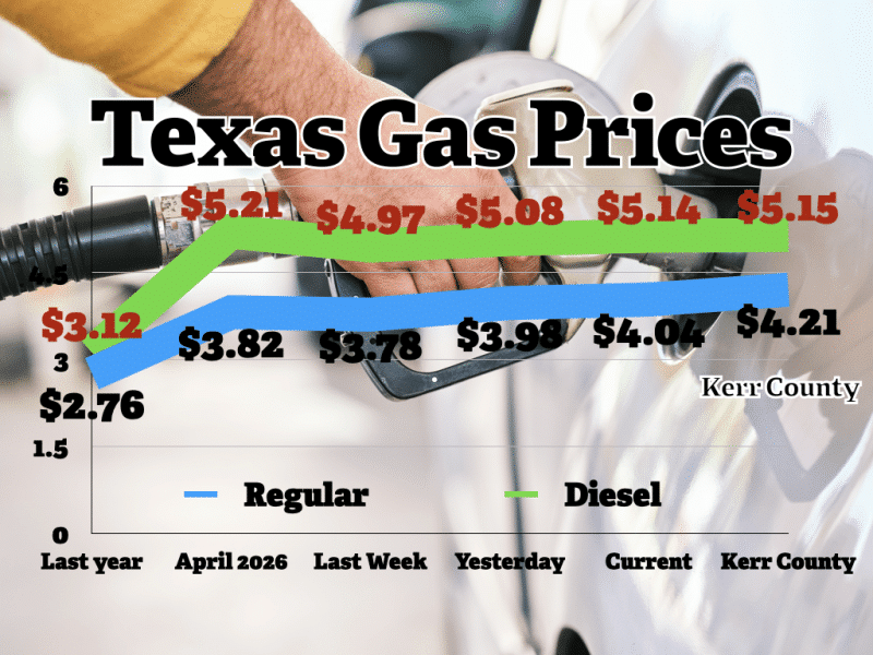
Kerr County gas now averaging $4.21; prices climb for third straight day
A year ago, Texans were paying an average of $2.76 per gallon, a roughly $1.28-per-gallon difference from today.
Comments (0)
There are no comments on this article.