Quarter-inch of ice forecast for Kerrville arrives at 6 a.m. on Saturday, creating hazardous continutions
A quarter-inch of ice represents a critical threshold where Ice Storm Warning criteria begins, according to the National Weather Service. At this accumulation level, ice coats surfaces like clear cement, trees begin shedding branches under the weight, and roads become extremely hazardous.
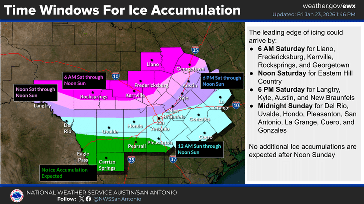
Kerrville is forecast to receive a quarter-inch of ice beginning as early as 6 a.m. Saturday and continuing through noon Sunday, enough to snap tree limbs, down power lines and cause isolated power outages across the Hill Country.
A quarter-inch of ice represents a critical threshold where Ice Storm Warning criteria begins, according to the National Weather Service. At this accumulation level, ice coats surfaces like clear cement, trees begin shedding branches under the weight, and roads become extremely hazardous.
“Ice can increase the weight of tree branches by 30 times,” according to meteorological research. At half an inch, a single power line span can add 500 pounds of extra weight.
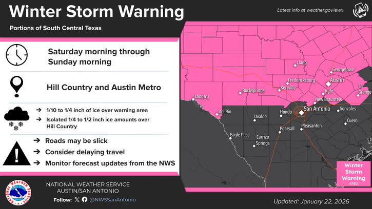
The Winter Storm Warning remains in effect for Kerr County from 6 a.m. Saturday through noon Sunday. An Extreme Cold Warning is in effect for all of South-Central Texas from Saturday evening through Monday morning.
30-Hour Ice Window
Kerrville faces one of the longest ice accumulation windows in the region at 30 hours, from 6 a.m. Saturday through noon Sunday. While icing will not be continuous during this period, the extended timeframe increases the potential for higher accumulation totals.
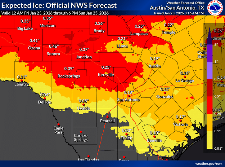
The forecast ice accumulation map shows varying totals across the Hill Country, with Kerrville expected to receive 0.25 inches, Junction 0.37 inches, Sonora 0.46 inches and Rocksprings 0.39 inches. San Antonio is forecast to receive 0.13 inches and Austin 0.19 inches.

What Quarter-Inch Ice Means
At a quarter-inch accumulation, impacts escalate rapidly. Cars and windshields become coated. Bridges turn especially hazardous. Stopping on roads becomes difficult. Tree limbs begin to snap under the weight.
Isolated power outages become possible, particularly when wind adds extra stress to ice-laden power lines and tree branches. Branches can become heavy enough to fall into power lines, or lines can fall on their own.
Roads become glazed and seriously impacted. Even walking outdoors becomes dangerous.
Unlike snow, ice coats surfaces and remains in place as long as temperatures stay below freezing. Some areas of Kerr County may remain below the freezing mark for more than 48 hours, meaning ice will persist on surfaces even after precipitation ends.
Before the Ice: Severe Weather Tonight
Before the dangerous cold and ice arrive, Kerr County faces a severe weather threat Friday evening as the Arctic front sweeps through the Hill Country between 8 and 9 p.m.
Several upper-level pulses of energy moving from northeast Mexico into the Rio Grande, combined with a low-level jet intersecting the frontal boundary, will result in scattered to numerous showers and thunderstorms. Some strong storms are possible capable of producing wind gusts of 40 to 50 mph and small hail.
Heavy downpours could lead to ponding of water on roadways, with some locations potentially receiving one to two inches of rainfall Friday night.
The frontal boundary will continue pushing southeast overnight with showers and storms along it until exiting the area by daybreak Saturday. Strong gusty winds of 25 to 35 mph are forecast in the wake of the boundary, with gusts up to 40 mph possible in some locations.
Rapid Temperature Crash
The cold airmass behind the boundary will push across the region overnight Friday, reaching the freezing mark around 6 a.m. Saturday over parts of the Hill Country. Cold rain or a mix of cold rain and freezing rain could occur at that time.
Temperatures are only expected to rise several degrees during late morning and early afternoon Saturday before plummeting into the upper 20s and lower 30s across the Hill Country and portions of the Interstate 35 corridor, including the Austin and San Antonio metro areas.
The Austin area could see freezing rain Saturday afternoon, while San Antonio experiences light cold rain initially.
Friday Forecast
Friday will remain cloudy with plenty of moisture in place. Highs are forecast to range from the mid-60s across the Hill Country to the mid-70s across the Coastal Plains. Rain chances remain across the area throughout the day, favoring areas along and east of Highway 77, the Hill Country and southern Edwards Plateau.
A Dense Fog Advisory remains in effect Friday morning as areas of drizzle and dense fog continue to produce visibilities of a quarter-mile or less.
Final Hours for Preparation
Residents have only Friday to complete final preparations before the Arctic front arrives tonight:
- Complete all supply shopping Friday morning
- Secure outdoor items ahead of strong winds tonight
- Prepare for potential severe weather this evening
- Protect exposed pipes before Saturday morning
- Bring pets indoors before temperatures plunge
- Fill vehicle gas tanks
- Charge all electronic devices
- Have alternative heating sources ready
- Check on elderly neighbors and vulnerable family members
All unnecessary travel should be avoided this weekend. Power outages are possible, and residents should be prepared to be without electricity for an extended period.
Wind chills could drop as low as 5 below zero in some Hill Country locations Saturday night, with most areas experiencing wind chills in the single digits and teens. Record low temperatures are possible Sunday and Monday.
Author

Related Articles
Winter Storm Warning issued for Kerr County as forecast models show increasing ice threat
The transition to freezing rain is now expected to occur Saturday morning across the Hill Country, with other areas in the warning zone seeing a changeover sometime Saturday afternoon or evening. Most areas within the Winter Storm Warning should see a transition to freezing rain by Saturday evening.
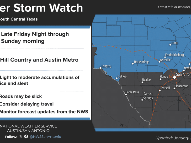
Winter Storm Watch, Extreme Cold Watch Issued for Kerr County as Life-Threatening Conditions Expected
The Winter Storm Watch is in effect from midnight Saturday through noon Sunday for areas roughly along and north of a line from Val Verde to San Marcos to La Grange, covering the Hill Country and northern Interstate 35 corridor including the Austin metro area.
Comments (0)
There are no comments on this article.