UGRA’s RiverHub dashboard goes live as first six flood sirens pass testing
The premise is simple: one place for information that used to live in a half-dozen places. “One of the things that was difficult with finding data in Kerr County was that it was scattered across seven, eight different web pages, different agencies,” Bushnoe said. “So we’ve taken all that data and brought it into one.”
Eleven months after the July 4, 2025, Guadalupe River flood killed 119 people across Kerr County, the Upper Guadalupe River Authority has pulled the region’s scattered river and rainfall data into a single public dashboard — and successfully tested the first six outdoor warning sirens built to alert people along the river.
UGRA General Manager Tara Bushnoe walked through the new system, called RiverHub, on The Lead Live this week, joined by two consultants on the project: Matt Ables, CEO of Kisters North America, which designed the dashboard, and Ivalu Rose, a civil engineer and certified floodplain manager with Kerrville’s IR² Engineering, who coordinated the civil work and siren installations.
The premise is simple: one place for information that used to live in a half-dozen places. “One of the things that was difficult with finding data in Kerr County was that it was scattered across seven, eight different web pages, different agencies,” Bushnoe said. “So we’ve taken all that data and brought it into one.”
RiverHub aggregates real-time precipitation and water-level readings from partners including the U.S. Geological Survey, the Lower Colorado River Authority and a Texas Tech University weather station, updating as fast as each gauge reports — intervals that range from one minute to 15 minutes depending on the source. The dashboard displays the last 365 days of data and links out to partner sites such as USGS for users digging into decades of records.
Visitors land on an interactive map of the Guadalupe River Basin, divided into standardized watershed segments known as HUCs, or hydrologic unit codes. Hovering identifies specific creeks and sub-basins; clicking a gauge — Cypress Creek, for instance — opens rainfall and height charts that users can drag to zoom, rescale by adjusting the axes, or pull as tabular data.
One design choice the team emphasized: RiverHub prioritizes water level, or height, over stream flow measured in cubic feet per second. Height, they said, is the metric that matters most for immediate flood safety and the one most people can read at a glance. Future versions will default to showing river heights against National Weather Service action stages — minor, moderate and major — for instant context.
The sirens
The hardware side reached a milestone this month. Rose said the team completed and tested Phase 1, installing six outdoor warning sirens and triggering them in a live test run by Kerr County’s new emergency management coordinator Shorey Harmon.
“We’re on track to complete Phase 1, and it’s really exciting,” Rose said. “We’ve installed six sirens and successfully tested all the components this June. We were all on a Zoom, with different team members on there, and we were right there when [the coordinator] triggered the sirens.”
Each siren runs about 120 decibels at the base of the pole, Rose said, with an effective range of roughly a mile in every direction down to 70 decibels — “and anything 70 and above is considered very loud.”
Bushnoe was direct about who the sirens are, and aren’t, for. “We have to remember these are outdoor warning sirens,” she said. “The populations they’re focused on are folks in more summer or recreation housing — cabins, RV parks, and areas where visitors gather near the river. If you’re in your home far away from a waterway, then you aren’t necessarily the target audience.”
To keep the sirens working when cell towers and internet fail during major storms — a failure point in the July 2025 disaster — they’re built on layered communication: VHF radio and LCRA’s private LTE network, constructed through the state’s Texas Middle Mile grant program, with satellite as a third backup.
Closing the South Fork gap
Before this project, Bushnoe said, the upper South Fork produced almost no data. In the past year, the team added two stations there: a full Texas Tech West Texas Mesonet weather station measuring wind speed, soil moisture, radiation and rainfall, and a new USGS gauge tracking precipitation and water height that has been operational since April.
For Rose, the work is personal. “This flood, and all floods, are very personal to me,” she said. “I’m very blessed to be a part of this team, to be able to help our community and other communities.”
A mobile-friendly version of RiverHub is expected within the next week and a half to two weeks, Ables said. Phase 2, beginning in the coming weeks, will identify sites for additional sirens and gauges. UGRA also plans to hand out a “What else would you like to see?” survey at its public meetings, letting residents weigh in on possible future features such as lightning-strike tracking, water-quality data and groundwater levels.
See it in person
UGRA will host three public meetings to demonstrate RiverHub and answer questions:
- Tuesday, June 23, 5:30 p.m. — Ingram Tom Moore High School cafeteria
- Thursday, June 25, 10 a.m. — Hunt Community Center
- Thursday, June 25, 5:30 p.m. — UGRA Lecture Hall
Author

Related Articles

Only 5 segments remain in Lead Live’s Fifth Annual Nonprofit Week
Forty-six organizations have already claimed spots for the Aug. 17-21 event, which airs live each morning from 8 a.m. to 1 p.m. on The Kerr County Lead’s Facebook and YouTube pages.
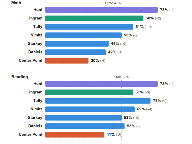
Kerr County’s elementary STAAR scores span a wide gap, with sharp swings inside Kerrville ISD
Hunt School led every campus in both subjects, though its grades of roughly 20 students make year-to-year movement unreliable. Ingram Elementary, far larger at about 265 students tested, was the most consistent strong performer, posting 68% in math, up two points, against the statewide grades 3-5 average of about 47%.

Flood-warning forums anchor the week, with ‘Frozen’ close behind
“Frozen Jr.” takes the Cailloux stage for three performances, opening Friday at 7:30 p.m., with a second evening show Saturday at 7:30 p.m. and a Sunday matinee at 2:30 p.m.

Comments (0)
There are no comments on this article.