Heavy rain, flood threat Wednesday-Thursday; officials briefed on severe weather
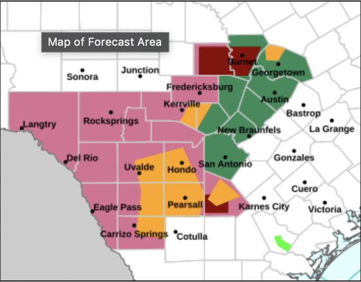
The Texas Division of Emergency Management presented a National Weather Service threat assessment showing the Hill Country under a marginal risk for flash flooding Wednesday, increasing to a slight risk Thursday.
State emergency management officials briefed Kerr County and Kerrville leaders Tuesday on an approaching storm system expected to bring heavy rainfall, potential flooding and isolated severe thunderstorms Wednesday through Thursday.
The Texas Division of Emergency Management presented a National Weather Service threat assessment showing the Hill Country under a marginal risk for flash flooding Wednesday, increasing to a slight risk Thursday. River flooding is also possible late Wednesday into Thursday.
Rainfall is expected to begin late Wednesday afternoon and continue through Thursday, with generally 0.5-1 inch across the region. However, forecasters warn locally heavy downpours could produce up to 3 inches Wednesday night into Thursday morning, with some areas potentially receiving 4 inches by Friday morning.
“Flash flooding in poor drainage areas” is possible, according to the briefing document. The Weather Prediction Center has placed the area under a marginal risk for excessive rainfall Wednesday and a slight risk — level 2 of 4 — Thursday.
Isolated severe thunderstorms are possible late Wednesday into Thursday, with hail the primary threat. The Storm Prediction Center has issued a marginal risk for severe weather, though forecasters note thunderstorms are not expected to become severe.
South winds of 10-15 mph with gusts up to 20 mph are expected ahead of the cold front, which should arrive Thursday evening.
The cold front will bring cooler, more seasonable November temperatures Friday through the weekend, with highs in the low-to-mid 70s and lows in the upper 40s.
Forecasters are monitoring a second storm system that could bring additional heavy rainfall Sunday into Monday, though considerable uncertainty remains about that system’s track and impacts.
Author

Related Articles

Lambert consolidates Uecker, Baroody voters to crush Hughes in Precinct 1 runoff
Lambert defeated Hughes 1,358 to 769 — 63.84% to 36.16% — in unofficial results released after 1 a.m. Wednesday following a hand count of Election Day ballots at the Kerr County Elections Administration.

Paxton routs Cornyn in Texas Republican Senate runoff; far-right candidates sweep statewide races
Paxton’s margin widened as the night went on, suggesting broad enthusiasm among the Republican primary electorate rather than a narrow base of committed supporters.
BREAKING NEWS: Storm bearing down on Comfort until 9 p.m.
Take shelter immediately if you are in or near Comfort, Center Point, Camp Verde or Cypress Creek.

Comments (0)
There are no comments on this article.