More wet weather in the forecast for the weekend
Tonight looks wetter. Showers and storms become likely before 1 a.m., with a 60% chance of rain and totals between a tenth and a quarter of an inch possible — again, higher under any stronger storms.
Kerr County isn’t done with the rain yet. A 50% chance of showers and thunderstorms lingers through this afternoon, with a high near 83 and southeast winds staying light. Rainfall totals should stay modest — less than a tenth of an inch for most — but any storm that develops could produce locally heavy downpours.
Tonight looks wetter. Showers and storms become likely before 1 a.m., with a 60% chance of rain and totals between a tenth and a quarter of an inch possible — again, higher under any stronger storms. Activity is expected to ease somewhat after midnight.
Saturday is more complicated. How the day plays out depends significantly on what happens tonight. Storm chances are real — 30% during the day and climbing back to 60% Saturday night — but organized activity is expected to stay mostly to the north, with the southern Edwards Plateau a possible exception during peak afternoon heating. Saturday’s high reaches near 86 before overnight lows settle around 72.
Then things quiet down. Sunday looks largely dry and sunny for Kerr County — partly sunny with a high near 89 and a south wind picking up to 10 to 15 mph with gusts to 20. The National Weather Service’s Austin/San Antonio office expects a drying trend to take hold through the weekend and into next week, with subtropical high pressure building back over Texas and pushing highs into the 90s with overnight lows in the 70s by early next week. Rain chances drop to low, confined mainly to areas along and east of I-35.
The stretch of wet weather that’s dominated the week’s forecast finally looks like it’s winding down — though if you’re near a low-water crossing today or tonight, the same rule applies: never drive into moving water.
Author

Related Articles

Screwworm returns to Texas as Kerrville’s revamped federal lab opens for the fight
The U.S. Department of Agriculture on Wednesday confirmed the detection of a New World screwworm in a calf in Zavala County, the first case in the United States and the first in Texas since the pest began pushing north out of Central America in 2023.

Texas airports rank among most stressful for families with kids, national study finds
A report by iSharing, a family location-tracking app, examined 30 major U.S. airports across nine factors and assigned each a composite stress score from 0 to 100, with higher scores indicating worse conditions for families traveling with children.
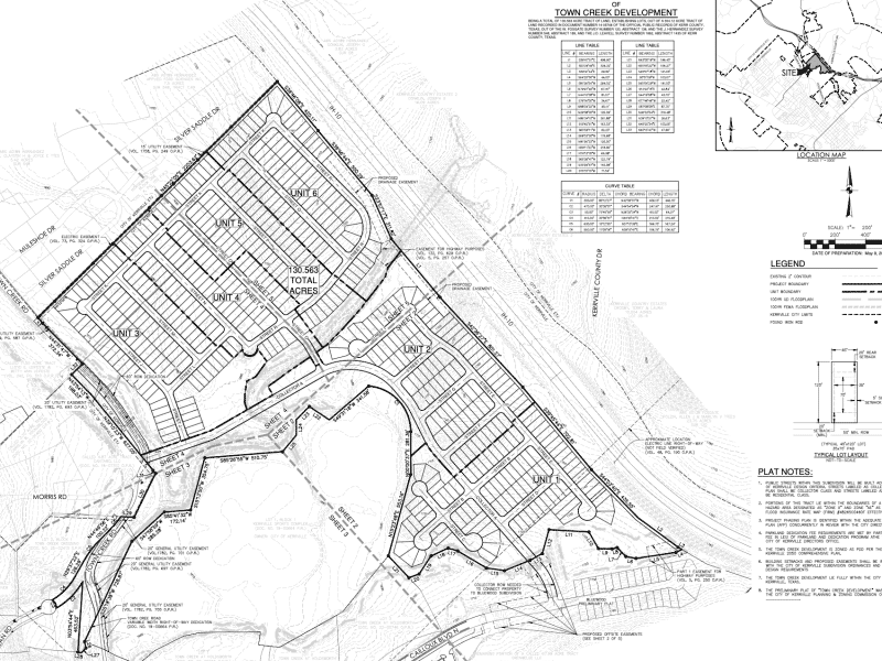
A roughly 500-home subdivision near the Sports Complex faces a key vote Thursday
The plat lays the development out in six phases, building from the Interstate 10 frontage south toward Holdsworth Drive and around the city-owned baseball fields.
Comments (0)
There are no comments on this article.