Winter Storm Watches, Warnings likely as dangerous ice, cold threatens Kerr County this weekend
The National Weather Service now forecasts “moderate to high probability” of a wintry mix of freezing rain and sleet beginning by 6 AM Saturday, with ice accumulations ranging from a trace to one-tenth of an inch. Areas of the Hill Country could see temperatures remain below freezing for 48 hours or more.
Winter weather watches and warnings are likely to be issued Wednesday for Kerr County as forecasters warn of a dangerous multi-day winter storm bringing significant ice accumulations, record cold, and life-threatening wind chills beginning Friday.
The National Weather Service now forecasts “moderate to high probability” of a wintry mix of freezing rain and sleet beginning by 6 AM Saturday, with ice accumulations ranging from a trace to one-tenth of an inch. Areas of the Hill Country could see temperatures remain below freezing for 48 hours or more.
“In summary, a very cold weekend into early next week period with dangerous cold temperatures and wind chill values in addition to the icy conditions and significant ice accumulations to make hazardous conditions and impacts to the local area,” forecasters stated early Wednesday.
While snow is expected to remain north of Kerr County, it could impact northern portions of the Hill Country, with possible snow flurries across the region Sunday before the wintry weather ends.
Timeline of the Storm:
Thursday: Dry and warmer, highs upper 60s to mid 70s—the last mild day before the Arctic blast
Friday: Strong Arctic front arrives mid to late afternoon with scattered showers and possible thunderstorms, temperatures begin falling
Friday Night: The cold airmass pushes across the Hill Country. By midnight, temperatures drop to freezing across much of the Hill Country, southern Edwards Plateau, and northern Val Verde County.
Saturday Morning (6 AM): Wintry mix of freezing rain and sleet begins with moderate to high probability. Precipitation chances 50-80%.
Saturday: Daytime highs struggle to reach only the upper 20s to lower 30s across the Hill Country and Austin metro area. Freezing rain and sleet continue during daylight hours. Wind chills drop to single digits by mid to late afternoon. Brief break in precipitation possible Saturday afternoon in some areas.
Saturday Night-Sunday Morning: More sleet returns. Temperatures plunge into the teens by mid-evening across much of the Hill Country and later across the I-35 corridor including Austin, with 20s elsewhere. Wind chills remain in single digits Sunday morning.
Sunday: Dangerous cold continues with highs only in the 20s to mid 30s. Possible snow flurries before wintry precipitation ends.
Monday: Temperatures slowly moderate with highs in upper 30s to 40s, but another hard freeze Monday night with lows dropping to the teens across the Hill Country, Austin metro, southern Edwards Plateau, and portions of Coastal Plains. San Antonio area could see lower 20s.
Tuesday Morning: Final period of freezing temperatures with lows in teens and 20s.
Dangerous Cold and Wind Chills:
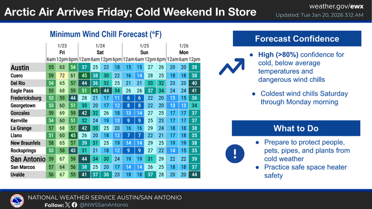
This will be the coldest weather of the season. Wind chills are forecast to feel like single digits beginning Saturday mid to late afternoon and continuing through Sunday morning. Moderate northerly winds will bring wind chill values to the teens across northern portions of the area including the Hill Country and southern Edwards Plateau.
Some areas across the Hill Country are likely to experience 48 hours or more of continuous freezing temperatures before temperatures finally rise above freezing Monday.
Ice Accumulation Threat:
While forecast ice accumulations of a trace to one-tenth of an inch may sound minimal, even small amounts of ice can create treacherous driving conditions, down power lines and tree branches, and cause power outages. The extended duration of freezing temperatures means ice will remain on surfaces for an extended period.
Areas south of San Antonio into the Coastal Plains face low confidence for freezing rain but moderate confidence for cold rain.
Protect the Four P’s—Prepare Now:
People:
- Stock up on food, water, medications, and supplies today or Thursday
- Have alternative heating sources ready
- Avoid all unnecessary travel this weekend
- Check on elderly neighbors and family members
- Charge electronic devices and power banks
Pets:
- Bring all animals indoors during extreme cold
- Provide warm shelter for livestock
- Ensure adequate food and unfrozen water
Plants:
- Cover or bring in sensitive plants before Friday evening
- Protect citrus and other cold-sensitive vegetation
Pipes:
- Insulate exposed pipes and outdoor faucets
- Know location of water shut-off valve
- During extreme cold, let faucets drip slightly
- Open cabinet doors under sinks to allow warm air circulation
- Disconnect and drain garden hoses
Additional Preparations:
- Fill vehicle gas tanks
- Ensure adequate heating fuel
- Have flashlights and batteries ready
- Keep cell phones charged
- Bring in outdoor furniture that could be damaged
Winter weather watches and warnings are expected to be issued on Wednesday. Residents should monitor the forecast frequently as details continue to be refined. Forecast conditions remain hazardous and life-threatening.
Author

Related Articles

Arctic front to bring freezing rain, dangerous cold to Kerr County this weekend
The National Weather Service forecasts a sharp temperature drop on Friday night, with lows plummeting to 27 degrees after a daytime high of 63. Saturday’s high is expected to reach only 36 degrees, with rain likely transitioning to freezing rain as the Arctic air settles over the region.

The Lead Live Podcast: Monday, Jan. 19, 2026
The episode featured Schreiner Communications Director Michael Bennett, Women’s Beach Volleyball Coach Hannah Thrasher, and Women’s Flag Football Coach Colby McCoy.
Comments (0)
There are no comments on this article.