
Forecasters: Up to 8 inches of rain possible in Hill Country as flood threat builds for Thursday
In its overnight forecast discussion, the NWS Austin/San Antonio office said widespread rainfall of 2 to 4 inches is possible Thursday into Friday, with local amounts up to 8 inches. Forecasters said models favor Thursday, Thursday night and early Friday morning for the highest totals.
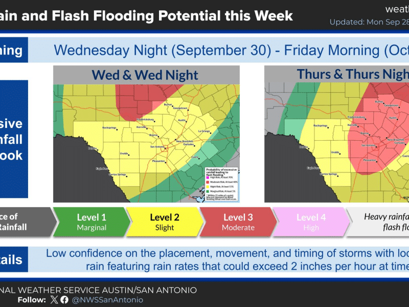
The Hill Country, including Kerr County, faces a significant risk of heavy rain and flooding Thursday into Friday. The National Weather Service on Tuesday issued its first rainfall estimates for the storm system fueled in part by the remnants of Hurricane Polo.
In its overnight forecast discussion, the NWS Austin/San Antonio office said widespread rainfall of 2 to 4 inches is possible Thursday into Friday, with local amounts up to 8 inches. Forecasters said models favor Thursday, Thursday night and early Friday morning for the highest totals.
The Weather Prediction Center has placed the Hill Country and the I-35 corridor under a Level 3 of 4 risk of excessive rainfall for Thursday. The rest of south central Texas is under a Level 2 risk.
Forecasters said models suggest a line of storms will develop early Thursday across the southern Edwards Plateau and northern Hill Country, then slowly expand east through the day. Some ensemble forecasts show the heaviest rain falling from the Rio Grande plains between Del Rio and San Antonio north into the Hill Country.
“We are still early in this event and as the hi-res members start to pick up on this, additional changes to the forecast are likely,” forecasters wrote.
The threat begins building Wednesday night, when rain is expected to spread from the west as a Pacific cold front slowly moves into the region. The WPC has placed areas along and north of a line from Del Rio to Austin, which includes Kerr County, under a Level 2 of 4 flood risk Wednesday night.
Forecasters said moisture levels are likely to climb to about 2 inches of precipitable water across most of the region, well above normal for this time of year. Some of that moisture comes from the remnants of Polo, whose low-level circulation is expected to emerge over far West Texas on Tuesday.
Much depends on how fast the front moves. The NWS said one model shows the front pushing south into the coastal plains early Friday, which would shift the heaviest rain farther east. Rain chances stay high Friday and continue through the weekend into Monday.
On Monday evening, Gov. Greg Abbott activated additional state emergency resources and said more than 1,900 state responders and more than 1,500 pieces of equipment are available to local officials, including swiftwater rescue teams and rescue helicopters. The State Operations Center moved to 24-hour operations Tuesday morning.
Abbott warned that rainfall totals could go higher if the front stalls over Central Texas. “Everyone should expect the rivers to rise,” he said.
Until the rain arrives, the heat continues. Highs Tuesday will range from near 90 to near 100, and Wednesday will be in the upper 80s to upper 90s, though forecasters said cloud cover could keep temperatures lower. By the weekend, highs are expected to fall to the mid 70s to lower 80s, with lows in the 60s.
The NWS urges residents to monitor the forecast, make sure they have multiple ways to receive warnings, and never drive through flooded roadways.
Author

Related Articles
Forecasters raise flash flood concerns for Wednesday night into Thursday
“Given the setup of deep moisture, a strong upper low and frontal boundary, this seems very reasonable,” forecasters wrote.

NWS: Strong thunderstorm moving through central Kerr County, threatens 40 mph winds and half-inch hail
Forecasters also warned of torrential rainfall that could lead to localized flooding, urging drivers not to cross flooded roadways, and said frequent cloud-to-ground lightning is occurring with the storm.

Schreiner’s defense holds on to win at Centenary for first road victory
The win moves Schreiner to 3-1 and gives the first-year program its first road victory. Its only other road trip was a 47-29 loss at Oklahoma Panhandle State on Sept. 12. Centenary fell to 0-3.
Comments (0)
There are no comments on this article.