
Flood Watch takes effect tonight as Kerr County braces for heavy rain
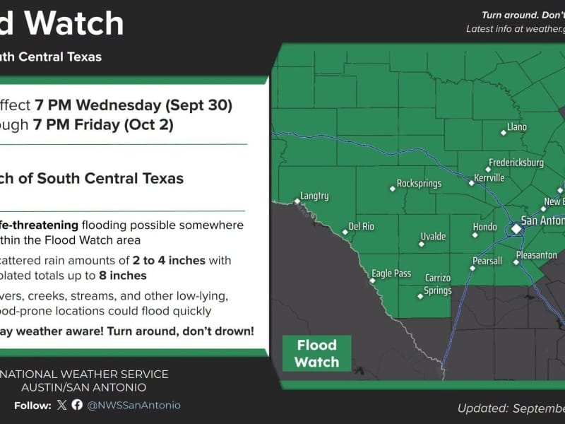
A Flood Watch for Kerr County and most of South Central Texas takes effect at 7 p.m. tonight and runs through 7 p.m. Friday. It opens a stretch of rain that forecasters have been tracking for more than a week.
A Flood Watch for Kerr County and most of South Central Texas takes effect at 7 p.m. tonight and runs through 7 p.m. Friday. It opens a stretch of rain that forecasters have been tracking for more than a week.
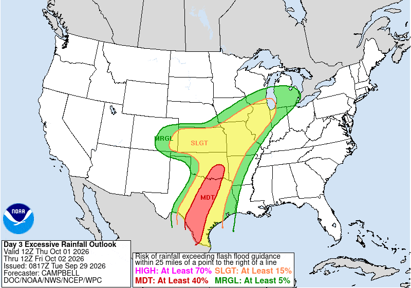
In an update Wednesday afternoon, the National Weather Service said it expects widespread totals of 1 to 4 inches, with isolated spots getting as much as 8 inches. The heaviest totals will lead to flash flooding, forecasters said. Some storms tonight and Thursday could also be severe, with damaging winds and large hail, and a tornado is possible.
The city of Kerrville, Kerr County and the state have spent the week getting ready.
A forecast that sharpened all week
Last week, forecasters were split on whether the rain would arrive midweek or slip to Friday. Much depended on how much moisture from Hurricane Polo, one of the strongest storms ever recorded in the eastern Pacific, would be pulled into Texas. The National Hurricane Center said then that Polo’s distant moisture could indirectly add to a heavy rain and flash flood threat in the Southwest.
Polo made landfall on Mexico’s Baja California peninsula early this week as a Category 2 hurricane, then moved into Sonora. Its moisture caused flash flooding and water rescues in Arizona on Tuesday.
By Monday, the NWS was calling a heavy rain and flash flood threat for Wednesday night into Thursday “very reasonable.” The agency issued the Flood Watch Tuesday morning for 28 counties, including Kerr, Bandera, Gillespie, Kendall, Real and Edwards. It named Kerrville among the places likely to see flooding.
What to expect
A Pacific cold front will push into the Hill Country tonight. The air ahead of it is unusually full of moisture: Wednesday morning’s weather balloon readings in Del Rio and Fort Worth were higher than about 90% of historical readings. That means storms can drop heavy rain quickly.
- Tonight: The front arrives in the northwest part of the region, and storms begin.
- Thursday: A line of storms crosses the region from northwest to southeast. This is the main window for heavy rain and possible severe weather.
- Friday morning: The front moves out and stalls along the coast. The watch stays in effect until 7 p.m. Friday.
- Weekend: Lighter rain chances linger, with Saturday highs in the 70s and 80s.
- Tuesday: Dry weather returns.
State teams staged in Kerrville
The state has moved help into Kerrville ahead of the storm. A Tuesday situation report from the Texas Division of Emergency Management lists two Texas Emergency Medical Task Force All Hazards groups assigned to Kerrville, each with 22 personnel and 11 pieces of equipment. A Texas Military Department ground transportation platoon is also activated there, with 10 personnel and five high-profile vehicles for reaching stranded motorists.
The State Operations Center in Austin has been running around the clock since Tuesday morning. Gov. Greg Abbott said Monday that more than 1,900 state responders and more than 1,500 pieces of equipment are available statewide.
“Everyone should expect the rivers to rise,” Abbott said.
City crews ready barricades, sandbags, rescue boat
The city of Kerrville moved to a higher level of readiness Tuesday, officials said.
- Barricades: Streets crews have staged barricades at low-water crossings, bridges and flood-prone roads, with more ready to go up.
- Sandbags: Streets and Parks and Recreation workers have filled several hundred sandbags and placed pallets of them in flood-prone areas.
- Drainage and repairs: Crews have cleared drainage areas and made temporary repairs to infrastructure damaged in earlier flooding. They’ll stay on standby through Sunday and can move to extended shifts.
- Rescue: Fire and EMS have a swift-water rescue boat staged for quick deployment. The city can also call on the state water-rescue teams in the area.
- Water system: Public Works is watching water and wastewater facilities and is prepared to shift how it runs the water system if flooding affects the surface water treatment plant.
- Shelters: Emergency Management is working with Kerr County and contacting designated shelter sites in case evacuations become necessary.
“Our priority is life safety,” city officials said. “Residents should remain weather aware, avoid unnecessary risks and be prepared to act if conditions change.”
Events postponed
- Kerrville Rotary Club Fellowship Social: Thursday’s social at the Heart of the Hills Heritage Center is postponed. Organizers said many guests would be crossing low-water crossings that could become unsafe. A new date will be set later.
- Notre Dame Catholic School Festival: Moved to Saturday, Oct. 10, starting at 5:30 p.m. on the festival grounds by the church. It includes a Patsy Torres concert and food booths. The raffle drawing stays on Saturday, Oct. 3, and will be livestreamed. The online auction runs Oct. 3 through Oct. 12.
What to know
- Flood Watch: 7 p.m. tonight through 7 p.m. Friday. A watch means flooding is possible. A Flood Warning means it’s happening or about to happen.
- Have more than one way to get warnings overnight, including phone alerts, a weather radio and local media.
- Never drive around barricades or through flooded roads. Water over a road can be deeper and faster than it looks. Check road conditions at DriveTexas.org.
Author

Related Articles

Kerrville steps up flood readiness ahead of Thursday’s heavy rain threat
City crews have staged barricades at low-water crossings, bridges and flood-prone roads, and more barricades are ready to go up as needed. Streets and Parks and Recreation workers have filled several hundred sandbags and placed pallets of them in flood-prone areas.
Flood Watch issued for Kerr County; state stages medical teams, National Guard vehicles in Kerrville
The watch, issued Tuesday morning by the NWS Austin/San Antonio office, covers 28 counties, including Kerr, Bandera, Gillespie, Kendall, Real and Edwards. Forecasters expect rainfall totals of 2 to 4 inches from Wednesday evening through Friday, with isolated amounts up to 8 inches. Kerrville is among the cities the NWS lists as likely to see flooding.
Forecasters: Up to 8 inches of rain possible in Hill Country as flood threat builds for Thursday
In its overnight forecast discussion, the NWS Austin/San Antonio office said widespread rainfall of 2 to 4 inches is possible Thursday into Friday, with local amounts up to 8 inches. Forecasters said models favor Thursday, Thursday night and early Friday morning for the highest totals.
Comments (0)
There are no comments on this article.